![]()
![]()
![]()
Use LEFT and RIGHT arrow keys to navigate between flashcards;
Use UP and DOWN arrow keys to flip the card;
H to show hint;
A reads text to speech;
93 Cards in this Set
- Front
- Back
- 3rd side (hint)
|
Reasons settlers came to North America |
Political, economic or religious they found a wilderness rich in diversity and natural resources . |
|
|
|
3 layers of the earth are called |
The crust, the mantle and the core |
|
|
|
The earth's crust is made of |
A thin layer of rock broken into large and small pieces called plates |
|
|
|
The mantle consists of molten rock called |
Magma |
|
|
|
The center of the earth is called |
The core - a hot dense sold mass |
|
|
|
Very thick material that slowly swirls around like boiling water causing the plates of the crust to move or break |
Magma |
|
|
|
The Canadian shield was formed by the action of |
Tectonic forces |
|
|
|
When two plates push together over millions of years they are called |
Fold mountains |
|
|
|
2 Examples of fold mountains are |
Rocky mountains and Appalachian mountains |
|
|
|
when the crust breaks while folding molten rock from the mantle pushes through up through the break causing a |
Volcano |
|
|
|
With each eruption molten rock cools creating what? |
Volcanic mountains |
|
|
|
2 examples of volcanic mountains are? |
The Canadian shield and the coastal rangers along the north American west coast . |
|
|
|
Tectonic forces built up the features of north america and what eroded them? |
The ice age |
|
|
|
Define glaciation |
Glaciation is when the earth was covered in glaciers- glaciers expanded and retreated for hundreds of thousands of years. Changing the landscape. |
|
|
|
How did glaciers change the landscape? |
A glacier was massive weighing millions of tons , literally a river of ice that slowly flows down hill scraping the earth. |
|
|
|
Most of the melted glaciers drained away into the oceans but some blocked by debris formed what? |
Lakes |
|
|
|
Much of the southern prairie were covered by lake agassiz which when it drained left behind flat bare land |
Lake agassiz. |
|
|
|
On some areas the Canadian shield glaciers scraped the rocks bare in other areas glaciers left mounds of debris called |
Hills |
|
|
|
An area with Similar characteristics is called |
Regions |
|
|
|
To do with the structure of the earths crust |
Tectonic |
|
|
|
Mountains created by the bending of rock layers |
Fold mountains |
|
|
|
Mountains created by breaks in the earth's crust |
Volcanic mountains |
|
|
|
To wear down the surface of the earth |
Erode |
|
|
|
Land being covered with thick moving ice |
Glaciation |
|
|
|
Plants that grow naturally in an area |
Vegetation |
|
|
|
The shape of the land is called |
Topography |
|
|
|
The prevailing conditions of the temperature and precipitation is called |
Climate |
|
|
|
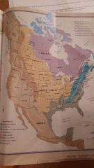
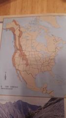
North America is divided into 8 physical regions .. they are.... |
Appalachian region Coastal plains Great lakes - st Lawrence lowlands Interior plains Canadian shield Western cordillera Intermountain region Artic region
Remember: A A I I C G W
|
|
|
|
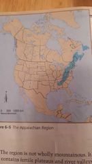
Appalachian mountains is located where |
East coast of north america |
|
|
|
What mountains extends 2400 kilometers from Newfoundland in the north west through the maritime provinces and south through the USA to Alabama and Georgia |
Appalachian mountains |
|
|
|
What mountain range is low because erosion reduced the sharp edges into hills and rolling mountains. It contains fertile plateaus and river valleys . Many deposits of coal oil and gas are found in its sedimentary layers of rock. |
Appalachian mountains |
|
|
|
Helps to create landscapes |
Erosion |
|
|
|
The climate of the Appalachian region is affected by two ocean currents they are?? |
The labrador current (bringing cold water south from the arctic causes freezing during winter) The gulf stream brings warm water from the Caribbean The meeting of these two currents also bring ideal breeding grounds for fish (more plankton, food etc) The grand banks was popular fishing spot for settlers |
|
|
|
When rain falls too fast for the earth to absorb the water carrots off soil creating channels and forming valleys , frozen water can pry apart rocks wind can also plat a part of wearing apart a surface... this is called? |
Erosion |
|
|
|
Originally the Appalachian region was heavily forested with both coniferous (always green) and deciduous (looses leaves in fall). Both could survive in poor mountain soil. Plants in different regions are called? |
Vegetation |
|
|
|
Ever green trees or shrubs bearing cones |
Coniferous |
|
|
|
Trees that shed their leaves |
Deciduous |
|
|
|
The type of rock formed by the erosion of other rocks after this loose material has hardened |
Sedimentary |
|
|
|
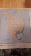
A low land area that stretches 3200 kilometers from Cape code along the Atlantic coast into Mexico |
The coastal plains |
|
|
|
The surface of the coastal plains is mostly flat or gently rolling - most is less then 30 meters above sea level.. making it contain many swamps and marshes. This creates fertile agricultural land. As well as providing transportation by rivers. |
Coastal plains |
|
|
|
This region starts with an A and is found on the east coast of north America |
The Appalachian region |
|
|
|
Low land aren that stretches from Cape cod to Florida and mexico |
The coastal plains |
|
|
|
The climate in the coastal plains is described as |
Cold snowy winters and hot humid summers in the northern part And southern is mild to warm winters and very hot dry summers - this area is subject to hurricanes |
|
|
|
Wet spongy land is called a |
Swamp |
|
|
|
Low land that is flooded in wet weather and almost always wet is called a |
Delta |
|
|
|
The soil of the coastal plains is very |
Sandy |
|
|
|
Violent wind storms that occur frequently. To be considered a ****** the winds must reach more then 120 km /hour they are causes by warm air as it rises then replaces by cool heavier air that blows in a spiral. |
Hurricane |
|
|
|
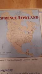
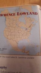
The smallest geographical area region in Canada is the |
The great lakes - st Lawrence lowland |
|
|
|
This area includes a triangle formed by lakes huron lake Ontario and lake Erie. This region contains many escarpments ( the best known is Niagara Falls escarpment. |
The great lakes - st Lawrence lowland |
|
|
|
The great lakes section of this region has a rolling landscape created by glaciaation. Flat plains are broken up by hills and deep river valleys . The st Lawrence portion has flat plains on either side of the river. |
The great lakes - st Lawrence region |
|
|
|
The climate here is essentially a humid continental climate - it is humid because of the lakes . The lakes hold heat on the summer keeping the air cool and and warm the air on the winter . Summers are cool to hot and winters are cool to cold |
The great lakes - st Lawrence region |
|
|
|
Originally this region had fertile soil and was heavily forested. Consisting of forests with broad leaves. |
Great lakes region |
|
|
|
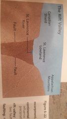
A valley that is created when when the portion of land between two faults drop (cracks in the earth) down |
Rift valley |
|
|
|
A steep cliff formed by erosion or faulting |
Escarpment |
|
|
|
A steep cliff formed by erosion |
Escarpments |
|
|
|
A climate type that developed away from the influence of oceans . The temperature range tends to be large and precipitation is low |
Contentinental climate |
|
|
|
A valley that is created when the portion of land between two flats drop down |
Rift valley |
|
|
|
Movement along a crack or cracks in the earths crust |
Faulting |
|
|
|
Describe the differences on how the great lakes were formed then the st Lawrence lowland. |
The st Lawrence was created by a rift valley (created by faulting) during the last ice age the st Lawrence lowlands sank and flooded. |
|
|
|
Why is the great lakes region the most popular region of canada - despite being the smallest? |
It has a mild continental climate and fertile soil |
|
|
|
Why is the great lakes and st Lawrence region favourable for agriculture? |
It has fertile soil and climate |
|
|
|
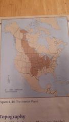
The interior plains are vast but not completely flat (it has gentle rolling hills and deep river valleys |
Interior plains |
|
|
|
This region is divided into central lowlands and the great plains the northern part is formed by the Canadian shield and the great lakes and the st. Lawrence river. |
The interior plains |
|
|
|
A brief but destructive storm characterized by a wind funnel |
Tornado |
|
|
|
The usual shape of a tornado, a tube of winds |
Funnel |
|
|
|
A mass of fluid or air that swirls in a rotary direction |
Vortex |
|
|
|
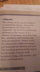
The climate of interior plains is continental meaning it has no 8nfluence by |
Oceans |
|
|
|
Contentinental climate can be described as what? |
Extreme summer , extreme winters |
|
|
|
Western cordillera mountains |
West coast |
|
|
|
Western cordillera climate |
|
|
|
|
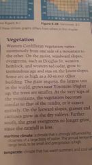
Western cordillera vegetation |
|
|
|
|
Climate that has warm summers and cool winters |
Temperate |
|
|
|
A climate that is strongly influenced by a large body of water , temperature range is small and precipitation is high. |
Maritime climate |
|
|
|
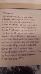
What is unusual about the climate in the western cordillera? |
It is a maritime climate - very mild and wet , the wettest region . Moderated by the Pacific |
|
|
|
What is unusual about the western cordillera vegetation? |
It varies enormously from one side of mountain slopes to the other . |
|
|
|
How does the western cordillera differ from the Appalachian region? |
The western cordillera is on the west coast the Appalachian is on the east coast , different climates, different vegetation |
|
|
|
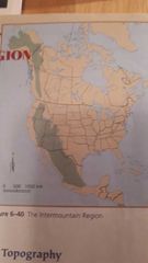
The intermountain region |
|
|
|
|
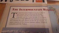
The intermountain region |
|
|
|
|
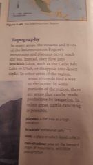
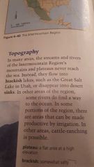
A flat area at high elevation |
Plateau |
|
|
|
Somewhat salty |
Brackish |
|
|
|
A place inslwhich liquid collects |
Sink |
|
|
|
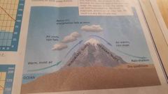
Area on the leeward slope of the mountains with little precipitation |
Rain shadow |
|
|
|
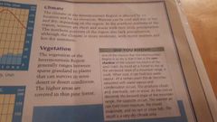
Intermountain region climate and vegetation |
|
|
|
|
The effects of rain shadow |
|
|
|
|
What are the greatest hindrances to human occupation of the intermountain region? |
|
|
|
|
What actions have humans undertaken to make this region more hospitable to human habitation? |
|
|
|
|
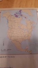
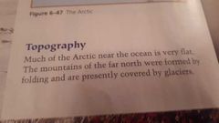
The artic |
|
|
|
|
The artic |
|
|
|
|
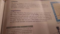
The artic climate |
|
|
|
|
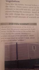
The artic |
|
|
|
|
How many day light hours are there in the artic over a year? |
Find out. |
|
|
|
Do a pmi on the advantages or disadvantages of living in the artic |

Example of a pmi chart |
|
|
|
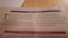
Conclusion of geographic regions of canada |
|
|