![]()
![]()
![]()
Use LEFT and RIGHT arrow keys to navigate between flashcards;
Use UP and DOWN arrow keys to flip the card;
H to show hint;
A reads text to speech;
16 Cards in this Set
- Front
- Back
|
Topographical Map Shape of the Earths surface and elevation changes are shown by contour lines Contour lines: join points of equal elevation |

|
|
|
Ways to Identify Topological and Topographical Maps |
Topographical Maps Title identifies region shown Contour lines for elevation changes Shading and graphics to indicate physical features Topological Maps Simplified maps with only key information so they are easy to read Use relative location - lack scale and distance |
|
|
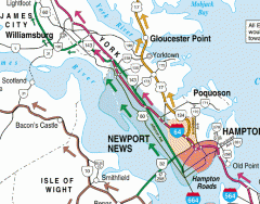
TOPOLOGICAL MAP |
|
|
|
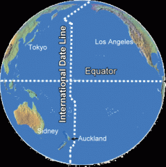
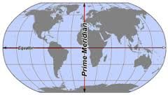
LONGITUDE Vertical Lines LATITUDE Horizontal Lines (equator) |
Prime Meridian: 0 degrees longitude Runs through France and Africa International Date Line: 180 degrees longitude (cuts through Russia and Alaska) Separates 2 consecutive calendar days |
|
|
International Date Line |
|
|
|
Prime Meridian |
|
|
|
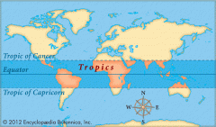
Tropic of Cancer 23 degrees North of Equator Tropic of Capricorn 23 degrees South of Equator Furthest point from the equator the sun can be seen directly overhead. |
|
|
|
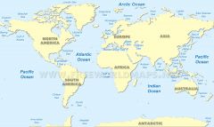
CONTINENTS Largest to smallest |
Asia Africa North America South America Antarctica Europe Australia |
|
|
OCEANS Largest to smallest |
Pacific - west coast Atlantic - east coast Indian - between Africa and Asia Southern - South Arctic - North |
|
|
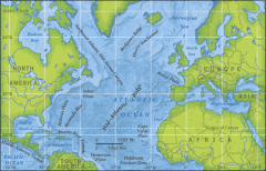
MAJOR SEAS Atlantic Ocean |
Caribbean Sea Mediterranean Sea Gulf of Mexico Hudson Bay |
|
|
MAJOR SEAS
Atlantic Ocean |
|
|
|
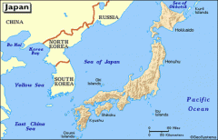
MAJOR SEAS Pacific Ocean |
South China Sea Bering Sea Sea of Okhotsk East China Sea Sea of Japan |
|
|
MAJOR SEAS Pacific Ocean |
|
|
|
OCEANS AND SEAS |
|
|
|
MAJOR RIVERS |
NILE RIVER Worlds longest river Located in Africa AMAZON RIVER Second longest river Located in South America Missouri River - longest river in U.S. |
|
|
MAJOR MOUNTAIN RANGES |
ASIA: HIMALAYAS MT. EVEREST- highest peak SOUTH AMERICA: ANDES EUROPE: ALPS AFRICA: KILIMANJARO (inactive volcano) NORTH AMERICA: Rockies (west) and Appalachian (east) |