![]()
![]()
![]()
Use LEFT and RIGHT arrow keys to navigate between flashcards;
Use UP and DOWN arrow keys to flip the card;
H to show hint;
A reads text to speech;
51 Cards in this Set
- Front
- Back
|
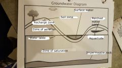
It is _____, not ___ that seeps down into the soil and does not run off into streams. |
precipitation runoff |
|
|
As the water seeps into the ground it fills ____ (air-filled openings between rock particles). |
pores |
|
|
This underground water that fills almost all the pores in rocks and sediment is called ______. |
groundwater |
|
|
Approximately __% of the Earth's liquid freshwater supply is stored beneath the surface as groundwater. |
90% |
|
|
A body of rock in which large amounts of water can flow and much water can be stored is called an ____. |
aquifer |
|
|
A rock that can hold a lot of water will only be an efficient aquifer if the ____ spaces are ____. |
pore connected |
|
|
The amount of water a rock can hold is determined by the ____. |
porosity |
|
|
Porosity is the percentage of ___ ____ in a given amount of rock or sediment. |
open spaces |
|
|
How tightly ____ the sediments are also affects porosity. |
packed |
|
|
The more ___ packed the sediments, the less pore space will be available. |
tightly |
|
|
The _____ of a rock of sediment indicates how freely water passes through pores. |
permeability |
|
|
For a rock to be permeable, the pores must be _____. |
connected |
|
|
A rock can have a high porosity, but if the pores are not connected, the rock is not _____. |
permeable |
|
|
Rocks that water cannot flow through are called ____ ___. |
impermeable rock |
|
|
_____ pulls water down through the soil and rock until it reaches a layer of ____ rock. |
Gravity impermeable |
|
|
As more water soaks into the ground, the level rises creating a zone of _____ (a layer where all the pores are filled with water). |
saturation |
|
|
The zone that lies between the water table and the surface is called the zone of ______. |
aeration |
|
|
The line separating the zone of saturation and the zone of aeration is called the ___ ____. |
water table |
|
|
Movement of groundwater depends on the permeability of the aquifer and the _____ of the water table. |
gradient |
|
|
The more ______ the rock, the faster the groundwater will flow through it. |
permeable |
|
|
The _____ the gradient, the faster the groundwater will flow through it. |
steeper |
|
|
The depth of the groundwater varies depending on the _____ of the land, permeability of the rock and the amount of _____. |
elevation rainfall |
|
|
During periods of increased rainfall, the water table ____. |
rises |
|
|
During _____, the water table lowers and flattens. |
droughts |
|
|
If the water table is higher than the elevation of the land, it will for a river or ___. This is called ____ water. |
lake surface |
|
|
The area where precipitation first enters the soil and infiltration occurs is called the _______ ___. |
recharge zone |
|
|
Under most surfaces there is usually only one _____. |
aquifer |
|
|
In some areas, an impermeable layer lies near the surface above the main aquifer. This rock layer prevents the water from seeping into the main aquifer. This layer is called a _____. |
aquiclude |
|
|
Water collects on top of the aquiclude creating a second zone of saturation above the main aquifer known as a _____ water table. |
perched |
|
|
|
|
|
A watershed is an area of land that drains to a ____ location. |
common |
|
|
A watershed can vary in size, they can represent the are draining to a small ____ or to the entire ocean. |
stream |
|
|
The ______ that falls into a watershed flows downward usually creating a stream or river. |
precipitation |
|
|
The area of land that contributes water to a stream or river is called a _____, or ____ _____. |
watershed drainage basin |
|
|
Small drainage basins generally contribute to _____, while that water from larger drainage basins come together to form large ___. |
streams rivers |
|
|
The watershed area for the ______ River covers a large portion of the central part of the US. |
Mississippi |
|
|
The area between two drainage basins is known as a drainage _____. |
divide |
|
|
In North America a massive drainage divide known as the _____ Divide separates the water that flows towards the ____ Ocean with water that drains toward the Gulf of ______, and towards the _____ Ocean. |
Great Pacific Mexico Atlantic |
|
|
The _____ Continental Divide runs along the high ridges and peaks of the ______ Mountains, and it separates land draining east to the ______ Ocean from that draining west and southwest to the Mississippi River, and the Gulf of Mexico. |
Eastern Appalachian Atlantic |
|
|
Eventually the water forms _____ which are small channels of water running across the surface of the landscape. |
rills |
|
|
The creation of rills happens much more quickly in areas where there is little ____. |
vegetation
|
|
|
____ ____ help to hold dirt and rocks in place, slowing the formation of rills. |
Plant roots
|
|
|
Eventually, many rills come together, forming larger _____. |
guillies |
|
|
There can get quite large, and help to feed large amounts of water into ____ and ____. |
streams rivers |
|
|
As water enters the floor of a _____, it typically is dumped into a river or stream. |
valley
|
|
|
Rivers and streams are moving bodies of _____ water that have a tremendous amount of ____. |
draining force |
|
|
Because of their strength, streams and rivers can cause a great amount of ______. |
erosion |
|
|
_____ _____ form alongside shallow meandering rivers. |
Flood plains |
|
|
As the rivers move back and forth across the landscape they form an area around the river where elevation of the land is ____ than other areas. |
lower |
|
|
This lower land around the river is known as a ________. |
floodplain |
|
|
During times of ____ precipitation, water leaves the banks of the river, but remains confined to the floodplain. |
excess |