Reading...
![]()
Play button
![]()
Play button
![]()
Use LEFT and RIGHT arrow keys to navigate between flashcards;
Use UP and DOWN arrow keys to flip the card;
H to show hint;
A reads text to speech;
153 Cards in this Set
- Front
- Back
|
The Polar Jet Stream is a westerly wind roughly located at the Polar Front.
|
True
|
|
|
Water is the most common compound on the Earth's surface.
|
True
|
|
|
Worldwide changes in sea level are called outgassing.
|
Flase
|
|
|
The sum of ice sheets, glaciers, and subsurface groundwater accounts for more than 99 percent of Earth's freshwater.
|
True
|
|
|
Lake Baykal, located in Siberian Russia, is the single largest body of freshwater on Earth.
|
True
|
|
|
The transition from liquid water to ice or ice to liquid water is called sublimation.
|
False
|
|
|
The water vapor content of air is called humidity.
|
True
|
|
|
The temperature at which air achieves saturation is called the sublimation temperature.
|
False
|
|
|
The dry adiabatic rate (DAR) is the rate at which an expanding, unsaturated parcel of dry air cools.
|
True
|
|
|
Air is saturated if it contains all of the water vapor that it can hold at a given temperature. This is also when the relative humidity reaches 100 percent.
|
True
|
|
|
The eight-sided appearance of ice crystals (e.g. snowflakes) reflects the structure of water molecules and the way they are arranged when water takes a solid form.
|
False
|
|
|
Water's "wetness," and many of its other important properties, are the result of the polarity of water molecules.
|
True
|
|
|
Assuming no change in the actual amount of water vapor in the air, as air temperature rises, relative humidity decreases.
|
True
|
|
|
Assuming no change in the actual amount of water vapor in the air, as air temperature rises, relative humidity decreases.
|
True
|
|
|
The moisture droplets in clouds average about 300 micrometers in diameter.
|
False
|
|
|
A lapse rate is a change of ___________ with height.
|
temperature
|
|
|
Suppose an air mass warms as it moves over a land surface, but no water vapor is added or lost. The relative humidity will ___________ while the specific humidty will ____________.
|
fall/not change
|
|
|
The Peru Current is a cold ocean current off the west coast of South America. If a warm, moist air mass passed over this current, ____________ might result.
|
advection fog
|
|
|
____________ is most likely when the environmental lapse rate is large (for example, 12 Celsius degrees/1000m).
|
Atmospheric instability
|
|
|
Descending air always warms at the _____________.
|
dry adiabatic lapse rate
|
|
|
The ____________ is the ratio of the actual amount of water vapor in the atmosphere to the maximum amount of water possible at that temperature.
|
relative humidity
|
|
|
Air that returns to its original position after an initial vertical displacement is called __________.
|
stable
|
|
|
A(n) _________ is an aggregation of tiny moisture droplets and ice crystals suspended in the air.
|
cloud
|
|
|
Clouds are usually classified on the basis of __________ and __________.
|
altitude/shape
|
|
|
Clouds that are flat and layered are in the general group called __________.
|
stratiform
|
|
|
The __________ process is the predominant cloud-forming process in the tropics, where clouds form above freezing temperatures.
|
collision-coalescence
|
|
|
The foggiest region of the United States is the ___________.
|
Pacific northwest
|
|
|
In unstable conditions, a parcel of air will __________ than the surrounding air.
|
rise because it is warmer
|
|
|
Assume a parcel of air at sea level (0 meters) has a temperature of 30 degrees Celsius. Further, assume that this parcel is forced upward to 2000 meters elevation, where the surrounding air temperature is 6 degrees Celsius. These conditions would be described as __________________. (Note: There are no clouds present in this scenario.)
|
unstable, because the parcel is warmer than the surrounding air
|
|
|
Assume that a parcel of air has an actual specific humidity of 8 g/kg and a relative humidity of 50%. This same parcel of air, then, would be able to hold ________ if it were completely saturated.
|
16 g/kg
|
|
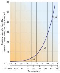
1.1 ......1 degree Celsius
1.2 ......10 degrees Celsius 1.3 ......20 degrees Celsius 1.4 ......30 degrees Celsius 1.5 ......40 degrees Celsius |
1.1 100%
1.2 50% 1.3 27% 1.4 14% 1.5 8.5% |
|
|
Match the following types of fog with their description and/or root cause.
2.1 evaporation fog 2.2 radiation fog 2.3 valley fog 2.4 advection fog 2.5 upslope fog |
2.1 forms over water bodies as water vapor comes in contact with the cold air above
2.2 forms at night over cold moist ground 2.3 forms as dense, cold air settles into low spots and depressions 2.4 can form as moist air moves horizontally over a cold ocean surface 2.5 forms a stratus layer of fog due to adiabatic cooling in mountain areas |
|
|
Match each term with the appropriate response.
3.1 vapor pressure 3.2 specific humidity 3.3 relative humidity 3.4 condensation nuclei 3.5 dew point |
3.1 generally measured in millibars
3.2 can be measured in grams of water per kilogram of air 3.3 the percentage of water vapor in the air compared to capacity 3.4 natural pollution required for cloud formation 3.5 the temperature at which air is saturated |
|
|
Weather data needed for synoptic analysis includes barometric pressure, dew point temperature, wind speed, and sea surface temperature.
|
False
|
|
|
As a result of orographic lifting, precipitation occurs on the windward slopes of mountain ranges and a rainshadow occurs on the leeward slopes.
|
True
|
|
|
A midlatitude cyclone is a vast, migrating low pressure system that is guided by the jet streams in the upper troposphere.
|
True
|
|
|
Mesocyclones often spawn tornadoes because they contract horizontally, causing winds to accelerate in an inward vortex.
|
True
|
|
|
As anybody who has seen the movie "Twister" or "The Wizard of Oz" knows, tornadic winds, while strong, are not strong enough to lift cattle, trucks, houses, or wicked witches into the air.
|
False
|
|
|
Tornadoes with a Fujita rating of F5 are less likely to cause severe damage than the rarer, and far more powerful F1 tornadoes.
|
False
|
|
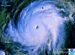
This satellite image shows Hurricane Mitch, a tropical cyclone that formed in the southern Caribbean Sea in October of 1998, ultimately strengthening into a Category 5 hurricane. For more information on Mitch, visit the image source.
|
True
|
|

Precipitation at Point C is likely to be higher than at A or B.
|
False
|
|

Latent heat released through condensation at Point B is probably higher than at A or C.
|
True
|
|
|
Chinook winds are the cool, upward airflows characteristic of the windward side of mountains.
|
False
|
|
|
__________ is the short-term, day-to-day condition of the atmosphere.
|
Weather
|
|
|
_____________ is the long-term average of weather conditions in a region.
|
Climate
|
|
|
__________ is the term which refers to air being forcibly pushed up a mountain slope.
|
Orographic lifting
|
|
|
A __________ is produced when a cold front overtakes a cyclonic warm front, wedging beneath it.
|
occluded front
|
|
|
Tornadoes are characterized by ________ atmospheric pressure at the core.
|
Extremely low
|
|
|
A __________ commonly results in the formation of towering cumulonimbus clouds.
|
cold front
|
|
|
__________ fronts travel faster than __________ fronts.
|
Cold/warm
|
|
|
Cyclonic storms and air masses move across the United States along __________, which shift in latitude with the seasons.
|
storm tracks
|
|
|
Of the list provided, __________ air masses tend to have the lowest specific humidity.
|
continental polar
|
|
|
In North America, most thunderstorms occur in areas dominated by __________ air masses.
|
maritime tropical
|
|
|
Match these Northern American summer air masses with their approximate average specific humidity.
1.1 Maritime Polar 1.2 Maritime Tropical 1.3 Continental Polar 1.4 Continental Tropical 1.5 Maritime Equatorial 1.6 Continental Arctic |
1.1 4.4g/kg
1.2 13-17g/kg 1.3 1.4g/kg 1.4 10g/kg 1.5 doesn't affect North America 1.6 0.1g/kg (generally only present in winter) |
|
|
Match these atmospheric lifting mechanisms with their basic cause.
2.1 convectional lifting 2.2 frontal lifting 2.3 convergent lifting 2.4 orographic lifting 2.5 hydrographic lifting |
2.1 involves air moves over a warm surface
2.2 involves collision of air masses of significantly different temperatures 2.3 involves collision of air masses as they move into a low pressure 2.4 involves collision of an air masses into a mountain slope 2.5 no such lifting mechanism exists |
|
|
The hydrologic cycle operates across the entire surface of the planet, from several kilometers below ground level to several kilometers above it.
|
True
|
|
|
As water evaporates from a lake surface, there is a release of latent heat to the lake, and a resulting increase in water temperature.
|
False
|
|
|
Potential evapotranspiration is the amount of water that would evaporate and transpire under optimum conditions (i.e., if water were constantly available).
|
True
|
|
|
Compared to an evaporation pan, a lysimeter is a simpler, but less accurate, device for determining potential evapotranspiration.
|
False
|
|
|
The wilting point is the point at which the soil contains only hygroscopic water, which cannot be accessed by plant roots.
|
True
|
|
|
As soil-moisture recharge removes soil water, plants must exert greater effort to extract the same amount of moisture.
|
False
|
|
|
Permeability is the amount of pore space in soil.
|
False
|
|
|
The zone of aeration is the part of the subsurface in which pores are not completely filled with water.
|
True
|
|
|
The height to which water can rise without the aid of pumps is referred to as the potentiometric surface.
|
True
|
|
|
A confined aquifer is less susceptible to surface pollution than is an unconfined aquifer.
|
True
|
|
|
The pore spaces within aquifers can collapse as a result of prolonged overpumping, causing the ground above them to subside.
|
True
|
|
|
Earth's largest known aquifer, the High Plains Aquifer, would require about 1000 years to recover from historic pumping if all groundwater mining stopped today.
|
True
|
|
|
__________ is/are the largest potential freshwater source(s) in the hydrologic cycle.
|
Groundwater
|
|
|
________ is defined as the penetration of water into the soil surface and subsurface.
|
Groundwater
|
|
|
__________ is inaccessible to plants because it is tightly bound to each soil particle.
|
Hygroscopic water
|
|
|
A well that brings water to the surface under its own pressure is called a/an __________.
|
artesian well
|
|
|
A/an __________ forms as a result of excessive drawdown and the lowering of the water table around a well.
|
cone of depression
|
|
|
After excess water drains from the larger pore spaces, the soil is said to be at __________.
|
field capacity
|
|
|
__________ streams are characteristic of dry regions where the water table is generally lower than the streambed.
|
Influent
|
|
|
The High Plains Aquifer has been pumped extensively and primarily for __________.
|
agricultural use
|
|
|
Waste dilution, wildlife preservation, and hydroelectric power production are all examples of __________ uses of water.
|
instream
|
|
|
On a worldwide basis, the majority of water withdrawal occurs for __________ use.
|
agricultural
|
|
|
A doubling of atmospheric carbon dioxide may increase the average global temperature by about 2 - 4 Celsius degrees.
|
True
|
|
|
A genetic classification of climate is based on causative factors such as interaction of air masses.
|
True
|
|
|
Climate may reasonably be defined as the average of weather conditions over a long period of time.
|
True
|
|
|
Carbon dioxide concentrations have increased measurably since the beginning of the Industrial Revolution.
|
True
|
|
|
An El Niño event is generally brought on by a strengthening of the trade winds in the eastern Pacific.
|
False
|
|
|
Climate has only changed in response to human activities. Prior to the Industrial Revolution, average temperature and precipitation values essentially remained constant.
|
False
|
|
|
Arid and semi-arid climates generally characterized by extremely high average temperatures and near complete lack of vegetation.
|
False
|
|
|
The increase in atmospheric methane over the past 150 years has been primarily a result of industrial sources.
|
False
|
|
|
As of 2004, the five warmest years in recorded history (since the use of reliable instrumentation began) occurred between 1995 and 2003.
|
True
|
|
|
The Polar and Highland climates encompass both Earth's high altitudes and high latitudes.
|
True
|
|
|
The Microthermal Climates experience very high temperature ranges related to continental locations and conflicts between air masses.
|
True
|
|
|
Worldwide, sea level is projected to decrease in response to the current trend of global warming.
|
False
|
|
|
The __________ climates have virtually no winter due to consistent day length and an almost perpendicular sun angle.
|
tropical
|
|
|
The __________ climates have distinct seasons, but generally average above freezing. Additionally, they are the location of over half (55 percent) the world's population.
|
mesothermal
|
|
|
Increased concentrations of greenhouse gases in the atmosphere __________.
|
are associated with increased temperatures in the lower atmosphere.
|
|
|
This forecast output from the the IMAGE 2.0 model shows the predicted change in average annual temperature, relative to what it was in 1970. Temperature change is likely to be greatest __________.
|
in the high latitudes
|
|
|
In ___________ climates, rainfall is low, highly variable, and undependable.
|
midlatitude cold steppe
|
|
|
The __________ climate type is a result of fairly constant subsidence (i.e., the subtropical high pressure belts).
|
desert
|
|
|
Moisture deficit is a predominant, semi-permanent characteristic of the __________ climate.
|
desert
|
|
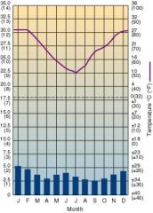
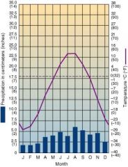
This climograph represents a location which is __________.
|
in the Southern Hemisphere
|
|
This climograph represents a location which is __________.
|
strongly influenced by the ITCZ in virtually all months
|
|
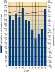
This climograph represents a location which is __________.
|
located at a high latitude, continental location in the Northern Hemisphere
|
|
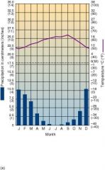
This climograph represents a location which is __________.
|
under strong influence of sub-tropical high pressure during summer months
|
|
|
The oldest rocks on Earth's crust tend to be located near the centers of ocean basins.
|
False
|
|
|
The Earth's lithosphere is comprised of fourteen moderate to large size plates, with numerous smaller pieces and microplates.
|
True
|
|
|
Marble, a metamorphic rock, is commonly derived from limestone that is exposed to extreme heat and pressure.
|
True
|
|
|
Plate tectonic processes include the subduction of heavier (more dense) continental crust under lighter (less dense) oceanic crust.
|
False
|
|
|
The rock granite is strongly associated with the ocean floors and the rocks beneath the continental masses.
|
False
|
|
|
The Hawaiian islands formed as a result of the sea floor spreading at a divergent plate boundary.
|
False
|
|
|
The entire mantle represents about 80% of the Earth's total volume.
|
True
|
|
|
Since Earth has no internal heat source, temperature decreases continually from Earth's crust all the way down to the core.
|
False
|
|
|
Magma is molten rock beneath the surface, while lava is molten rock which has been extruded onto the surface.
|
True
|
|
|
Transform plate boundaries can occur where plates slide past each other at right angles to a sea-floor spreading center.
|
True
|
|
|
Chemical and clastic are terms usually associated with metamorphic rocks.
|
False
|
|
|
Alfred Wegener's ideas regarding the movement of continents were widely accepted immediately after he published them in 1915.
|
False
|
|
|
Vertical movements of the Earth's crust related to the buoyancy of Earth materials are explained by the principle of __________.
|
isostacy
|
|
|
Lithosphere is comprised of Earth's _____________.
|
crust and uppermost mantle
|
|
|
From the surface down to the core, the density of Earth materials _________ .
|
increases continuously
|
|
|
Earth's age is estimated by scientists to be ________ years.
|
4,600,000,000
|
|
|
We are currently living in the _____________ period of the _____________ era.
|
quaternary / cenozoic
|
|
|
____________ is the primary scientific method used to determine absolute ages for crustal rock that is millions or billions of years old.
|
radiometric dating
|
|
|
Some of the most common intrusive igneous rocks, listed in order from ultra-mafic to felsic, include ________________.
|
Peridotite, Gabbro, Diorite, and Granite
|
|
|
Conglomerate, Sandstone, Siltstone, and Shale are _________ rocks which are primarily distinguished by differences in __________.
|
clastic sedimentary / grain size
|
|
|
Lithospheric plates move at roughly __________, with some slightly faster and some slightly slower.
|
5 centimeters per year
|
|
|
The world's deep ocean trenches coincide with _________.
|
subduction zones
|
|
|
Match each description with the best term.
1.1 molten rock beneath the Earth's surface 1.2 molten rock extruded onto the Earth's surface 1.3 any intrusive igneous body of rock 1.4 a type of intrusive igneous rock 1.5 a type of extrusive igneous rock 1.6 a pluton with a surface are greater than 100 square kilometers |
1.1 magma
1.2 lava 1.3 pluton 1.4 granite 1.5 basalt 1.6 batholith |
|
|
Match each description with the best term.
2.1 transform plate boundary 2.2 convergent plate boundary 2.3 divergent plate boundary 2.4 volcanic activity related to a hot spot 2.5 volcanic activity related to a subduction zone |
2.1 San Andreas Fault, California
2.2 Andes Mountains, South America 2.3 Rift Valley, East Africa 2.4 Mauna Loa, Hawaii 2.5 Mt. Pinatubo, Philippinees |
|
|
Most of the Earth's surface is actually below sea level.
|
True
|
|
|
This image from ARC Science Simulations shows three scenes of North America at increasing levels of detail. Second order relief features, such as the Rocky Mountains, Great Salt Lake, and the horst and graben topography of the Great Basin, are evident in the middle image.
|
True
|
|

The creation of the Himalaya Mountains (H) is a prime example of extensional orogenesis.
|
False
|
|
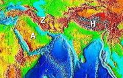
Both the Zagros (Z) and Himalaya ranges are examples of oceanic plate-continental plate orogenesis.
|
False
|
|
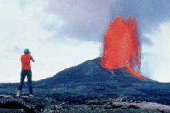
The person in the photograph might be in danger from pyroclastic flows (common in subduction zones like the one in which this photograph was most likely taken).
|
False
|
|
|
In time, the low viscosity lava fountain shown will produce a landform such as this one. (Source)
|
True
|
|
|
Over thousands of years, the same landform will look like this one.
|
False
|
|
|
Earthquakes associated with faulting are called tectonic earthquakes.
|
True
|
|
|
The Moment Magnitude scale measures earthquake intensities on a logarithmic scale.
|
True
|
|
|
The San Andreas fault is a strike-slip fault and occurs at the boundary between the Pacific and North American plates.
|
True
|
|
|
The epicenter of an earthquake is the point at which fault slippage actually occurs and is usually located deep within the lithosphere.
|
False
|
|
|
Despite the fact that many large population centers are located in tectonically and volcanically active areas (for example, Tokyo, Manila, Los Angeles, Naples...), such hazards pose little danger to humans.
|
False
|
|
|
Normal faults result from tensional forces pulling rocks apart, while reverse faults are caused by compressional forces associated with plate convergence.
|
True
|
|
|
The Red Sea was formed as the Arabian Peninsula rifted apart from Africa. As expected, this region has many examples of normal faults.
|
True
|
|
|
Slowly migrating pieces of the Earth's crust that have become attached or accreted to continental plates are called __________.
|
terranes
|
|
|
The Basin and Range regions of the western United States are a result of __________.
|
the formation of horsts and grabens
|
|
|
Horizontal movement along a fault plane is called a __________ fault.
|
strike-slip
|
|
|
_________ is an example of first order relief.
|
A continental platform
|
|
|
The Sierra Nevada of California and the Grand Tetons of Wyoming are examples of __________.
|
tilted fault block mountain ranges
|
|
|
Volcanism usually does not occur __________.
|
along the convergent boundary where two continental plates collide
|
|
|
__________ result(s) from compression stress like that found at convergent plate boundaries.
|
folding
|
|
|
Flood basalts are associated with __________.
|
effusive eruptions and hot spots
|
|
|
__________ record vibrations in the Earth's crust that may be associated with earthquakes.
|
Seismographs
|
|
|
An anticline is a type of __________.
|
fold
|
|
You are looking down from a helicopter on a small road in the desert. A major earthquake has just split the road, leaving the lanes looking like this. Since there doesn’t seem to be any vertical displacement, this is probably a _________ fault.
|
right lateral strike-slip
|
|
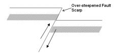
This fault, shown here in a profile (sideview) diagram, would most likely be found in association with a _________ plate boundary.
|
convergent
|
|

This is a hypothetical map of locations along the San Andreas Fault in California.
Which two locations will move next to each other (become adjacent) in the shortest period of time? |
W and Z
|
|
|
Match each term with the appropriate definition.
1.1 molten rock material 1.2 basin-shaped depression associated with the collapse of a volcanic mountain 1.3 circular surface depression near the summit of a volcano 1.4 cone-shaped hill formed from pyroclastic material and scoria 1.5 steep-sided mountain formed from an explosive eruption 1.6 gently-sloping mountain formed from an effusive eruption |
1.1 lava
1.2 caldera 1.3 crater 1.4 cinder cone 1.5 composite volcano 1.6 shield volcano |
|
|
Match each process or landform with the region in which it occurs.
2.1 The Appalachian Mountains 2.2 The Himalayas 2.3 The Rift Valley, Africa 2.4 The Big Island, Hawaii 2.5 southern California 2.6 The Cascade Mountains |
2.1 folding
2.2 continental plate collision orogenesis 2.3 horsts and grabens 2.4 shield volcanoes 2.5 faulting 2.6 composite volcanoes |