![]()
![]()
![]()
Use LEFT and RIGHT arrow keys to navigate between flashcards;
Use UP and DOWN arrow keys to flip the card;
H to show hint;
A reads text to speech;
61 Cards in this Set
- Front
- Back
|
What is a River? |
A...
|
|
|
Where does a body of Water come from? |
Rainfall, springs, or melting snow/ice. |
|
|
Where do Slopes come from? |
Volcanic or tectonic processes. |
|
|
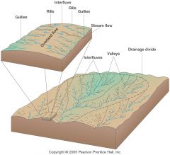
Where do Physically Distinct Channels come from? |
From erosive action of overland flow. |
|
|
What is Overland Flow? |
When the amount of rain exceeds the surfaces ability to soak it up, you get water flowing over the surface. |
|
|
What can Overland Flow do? |
Erode the surface into rills, gulleys, and ultimately a full-fledged stream or river channel.
|
|
|
What is Infiltration Capacity? |
How quickly water can soak into the ground. |
|
|
What determines Surface Flow? |
|
|
|
What questions help determine the erodibility of a surface? |
|
|
|
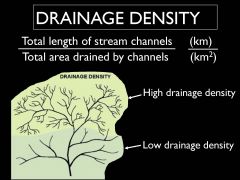
What does Drainage Density depend on? |
|
|
|
What is Drainage Density? |
|
|
|
What is a good example of a surface with very high drainage density? |
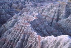
South Dakota Badlands |
|
|
Why will some surfaces have a very high drainage density? |
|
|
|
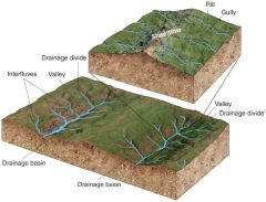
What is a Drainage Divide? |
|
|
|
What are the three types of Drainage Divide? |
|
|
|
What is a Drainage Basin? |
|
|
|
What is a Stream Channel? |
A long narrow depression eroded by the stream into rock or sediment.
|
|
|
What sizes are Drainage Basins? |
|
|
|
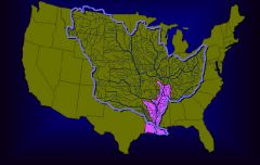
How is the US characterized? |
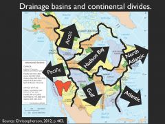
By very large drainage divides (continental divides) which separate very large-scale drainage basins.
|
|
|
What do the Rocky Mountains form? |
A divide separating the Pacific drainage from the Gulf/Atlantic drainage. |
|
|
What are Drainage Patterns? |
|
|
|
What is a Tributary? |
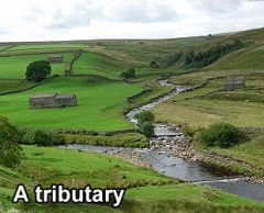
A small stream flowing into a larger one.
|
|
|
Where do branches (tributaries) flow? |
Branches flow to the main stream. |
|
|
What are the four Drainage Patterns? |
|
|
|
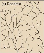
Define: Dendritic drainage pattern. |
|
|
|
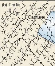
Define: Trellis drainage pattern. |
|
|
|
Define: Parallel drainage pattern. |
|
|
|
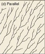
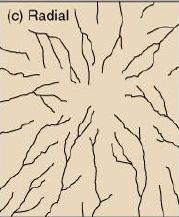
Define: Radial drainage pattern. |
|
|
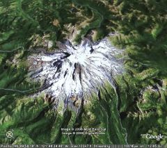
What drainage pattern is shown in this picture of Mt. Rainier, Washington?
|
Radial Drainage Pattern |
|
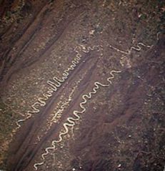
What drainage pattern is shown in this picture of the Shenandoah River?
|
Trellis Drainage Pattern |
|
|
What is the formula to measure River Discharge? |
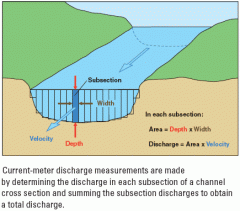
Q = w * d * v
|
|
|
What do the letters in the River Discharge Formula stand for? |
Q (discharge) = w (width) * d (depth) * v (velocity) |
|
|
How can the River Discharge Formula also be expressed? |
Q (discharge) = a (area) * v (velocity) |
|
|
Fill in the blanks:
Discharge is a unit ______ per unit ______. Which is typically______ per second, or ______ per second. |
Discharge is a unit volume per unit time. Which is typically cubic meters per second, or cubic feet per second. |
|
|
Where can cross-sectional areas be hard to measure? |
|
|
|
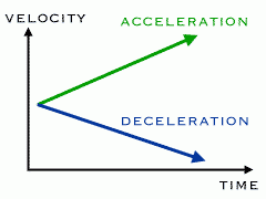
Define: Velocity. |
|
|
|
Why is Velocity taken as an average? |
Because velocity patterns vary across a river's cross-section. |
|
|
What does friction with bed and banks mean? |
That the water is moving slowest close to the bed and banks, and faster as you get further away from them. |
|
|
Where does the fastest flow occur in a river? |
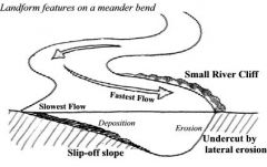
In the middle of the river, near the surface.
|
|
|
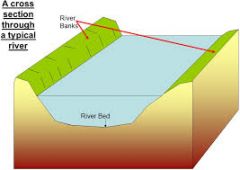
What is a rivers cross-section? |
|
|
|
In a cross-sectional area, what occurs with velocity? |
As the area of a channel decreases, velocity increases. |
|
|
When does velocity vary? |
As channel shape changes. |
|
|
Regarding Velocity
What does it mean when a river is at low flow? |
|
|
|
Regarding Velocity
What happens as a river fills up? |
|
|
|
When does a river tend to fill up quite easily? |
When it is at low flow. |
|
|
What happens when a rivers efficiency increases? |
It becomes harder to raise the level of the river. |
|
|
What do river channels tend to adjust? |
The amount of water they receive. |
|
|
What happens if a river is constantly at low flow? |
It will silt up and the channel will become smaller. |
|
|
What will happen if a river is constantly at bank-full discharge? |
It will be moving very fast and therefore eroding, increasing the size of the channel. |
|
|
Define: Erosion |
Physically picking up sediment.
|
|
|
What are rivers part of? |
A Drainage Basin System |
|
|
Can the happenings of a Drainage Basin have great effects on a river? |
Yes |
|
|
Does a channels shape affect a river's velocity? |
Yes
|
|
|
Define: Drainage Basin System |
|
|
|
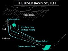
How water gets into river channels
Method 1/4: Direct |
Method One
Note: Not all that important as a water source, because the surface area of the river's channels is small in comparison to the surface area of the basin as a whole. |
|
|
How water gets into river channels
Method 2/4: Throughflow |
Method Two
|
|
|
How water gets into river channels
Method 3/4: Groundwater Flow |
Method Three
Note: Water is very slow getting into the river channel this way. |
|
|
How water gets into river channels
Method 4/4: Overland or Surface Runoff |
Method Four
Note: Water is fast getting into the river channel this way. |
|
|
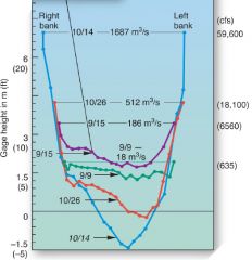
Define: Storm Hydrograph |
A chart showing a rivers response to a rainstorm. |
|
|
When a drainage basin primarily gets it water from overland flow how will it respond in a rainstorm? |
|
|
|
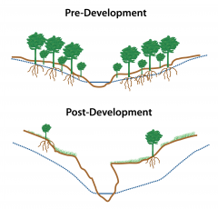
Does urbanization increase flood risk downstream? |
Yes typically because impermeable surfaces (tarmac, parking lots, storm drains) force water to travel by overland flow into the river channel.
|