![]()
![]()
![]()
Use LEFT and RIGHT arrow keys to navigate between flashcards;
Use UP and DOWN arrow keys to flip the card;
H to show hint;
A reads text to speech;
150 Cards in this Set
- Front
- Back
|
Alluvial fans in humid areas and arid climates. |
Alluvial fans in humid areas show normally low cones with gentle slope from head to toe and they appear as high cones with steep slope in arid and semi-arid climates |
|
|
difference between alluvial fans and deltas |
Unlike in alluvial fans, thedeposits making up deltas are very well sortedwith clear stratification. The coarsest materialssettle out first and the finer fractions like siltsand clays are carried out into the sea. |
|
|
Natural levees |
Natural levees arefound along the banks of large rivers. They arelow, linear and parallel ridges of coarse depositsalong the banks of rivers, quite often cut intoindividual mounds. |
|
|
Point bars |
Point bars are also known as meander bars.They are found on the convex side of meandersof large rivers and are sediments deposited ina linear fashion by flowing waters along thebank |
|
|
lateral erosion is more when the slope is |
gentle |
|
|
factors of meander formation |
1. gentle slope 2. unconsolidated deposit 3. coriolis force |
|
|
cut-off bank and slip off bank |
The concave bank is known as cut-off bankwhich shows up as a steep scarp and theconvex bank presents a long, gentle profile andis known as slip-off bank |
|
|
braided pattern |
when discharge is less and loadis more in the valley,water flow is dividedinto multiple threads. These thread-like streamsof water rejoin and subdivide repeatedly |
|
|
doline |
collapse sinks |
|
|
Uvalas/valley sinks |
Uvalas are large sinkholes formed by the joining of several smaller sinkholes |
|
|
Stalactites and Stalagmites |
Stalactites hang as icicles of differentdiameters. Stalagmites rise upfrom the floor of the caves. |
|
|
glacial landforms |
cirque-deep troughs horns-3 or more cirques meet aretes- saw toothed ridges |
|
|
examples of radiating cirques |
Matterhorn in the alps and Mt. Everest in the himalayas |
|
|
fjords |
Very deepglacial troughs filled with sea water andmaking up shorelines (in high latitudes) arecalled fjords. |
|
|
glacial till |
The unassorted coarse and fine debris droppedby the melting glaciers is called glacial till. |
|
|
outwash deposits |
glaciofluvialdeposits are called outwash deposits. |
|
|
till deposit vs outwash deposit |
Unlike till deposits, the outwash deposits areroughly stratified and assorted. |
|
|
Moraines |
Moraines They are long ridges of deposits of glacial till |
|
|
Lateral moraines |
Lateralmoraines form along the sides parallel to theglacial valleys. |
|
|
Drumlins |
Drumlins Drumlins are smooth oval shaped ridge-likefeatures composed mainly of glacial till withsome masses of gravel and sand. The long axesof drumlins are parallel to the direction of icemovement. They may measure up to 1 km inlength and 30 m or so in height. One end ofthe drumlins facing the glacier called stoss is steeper and blunter than the tail. |
|
|
two types of coastal landforms |
high,rocky coasts low,smooth and gently sloping sedimentary coasts(emerged coasts) |
|
|
low sedimentary coasts |
coastal plains and deltas- eg: lagoons and tidal creeks |
|
|
Deflation |
Deflation includes lifting and removal of dustand smaller particles from the surface of rocks. |
|
|
pediments |
rocky floors at the foot of mountains |
|
|
inselberg |
remnant of a mountain |
|
|
pediments and pediplains |
pediplain, broad, relatively flat rock surface formed by the joining of several pediments. |
|
|
playas |
shallow lakes formed on plains at the centre of a basin |
|
|
barchans |
Crescent shaped dunes called barchanswith the points or wings directed away fromwind direction i.e., downwind, |
|
|
Parabolic dunes |
Parabolic dunesform when sandy surfaces are partially coveredwith vegetation. That means parabolic dunesare reversed barchans with wind directionbeing the same. |
|
|
Seif |
Seif is similar to barchan witha small difference. Seif has only one wing orpoint. This happens when there is shift in windconditions. |
|
|
Longitudinal dunes |
Longitudinal dunes formwhen supply of sand is poor and winddirection is constant. |
|
|
Lapies |
Lapies a horizontal surface of exposed limestone in which the joints have been enlarged |
|
|
RiversAlkananda and Bhagirathi join to make ___ at _______ |
RiversAlkananda and Bhagirathi join to makeriver Ganga near Deoprayag. |
|
|
oxygen is found upto height carbon dioxide and water vapour are found upto |
120 km-oxygen 90 km- CO2 and water vapour |
|
|
Top four gases in atmosphere |
Nitrogen Oxygen Argon Carbon dioxide |
|
|
ozone is found upto height |
10 to 50 km |
|
|
Watervapour also decreases from _______ towards ______ |
Watervapour also decreases from the equatortowards the poles. |
|
|
Higher concentration of dust particles is found in |
Thehigher concentration of dust particles is foundin subtropical and temperate regions due todry winds in comparison to equatorial andpolar regions. |
|
|
Thickness of the troposphere is greatest at |
Thickness of the troposphere is greatest at theequator because heat is transported to greatheights by strong convectional currents. |
|
|
ozone layer is in |
stratosphere |
|
|
ionosphere-helps in |
It contains electrically charged particles knownas ions, and hence, it is known as ionosphere.Radio waves transmitted from the earth arereflected back to the earth by this layer. |
|
|
earth receives calories per sq.cm per minute at the top of its atmosphere |
earth receives 1.94 calories per sq.cm per minute at the top of its atmosphere |
|
|
aphelion is on and perihelion is on |
3rd january and 4th june |
|
|
The factorsthat cause these variations in insolation are : |
The factorsthat cause these variations in insolation are : (i)the rotation of earth on its axis; (ii) the angle ofinclination of the sun’s rays; (iii) the length of theday; (iv) the transparency of the atmosphere; (v)the configuration of land in terms of its aspect |
|
|
Maximum insolation is received over |
Maximum insolationis received over the subtropical deserts, wherethe cloudiness is the least. Equator receivescomparatively less insolation than the tropics |
|
|
Generally, at the same latitude the insolationis more over |
Generally, at the same latitude the insolationis more over the continent than over the oceans. |
|
|
The convective transfer of energy is confined |
Theconvective transfer of energy is confined onlyto the troposphere. |
|
|
The transfer of heat through horizontalmovement of air is called |
The transfer of heat through horizontalmovement of air is called advection. |
|
|
loo’ is the outcome of |
advection process. |
|
|
terrestrial radiation |
This energy heats up theatmosphere from below. This process is knownas terrestrial radiation |
|
|
The earth as a whole does not accumulate or loose heat. It maintains its temperature.how? |
The earth as a whole does not accumulate or loose heat. It maintains itstemperature. amount of heat received in the form of insolationequals the amount lost by the earth throughterrestrial radiation. |
|
|
Heat budget of earth |
35 is reflected back by atmosphere 65 is absorbed-14 by atmosphere and 51 by earth's surface 65 reaches earth and 65 is reflected out as well. |
|
|
heat deficit and heat surplus regions |
40 N to 40 S-heat surplus pole region- heat deficit |
|
|
In January theisotherms deviate to the north over the oceanand to the south over the continent. |
Due to differential heating of land and ocean. and effect of ocean currents |
|
|
Isotherms are more or less parallel in |
southern hemisphere |
|
|
normal lapse rate |
temperature decrease with altitude |
|
|
inversion of temperature |
temperature increases with altitude. happens in winter with clear sky and still air.This occurs when the earth is cooler than air above. aka valley inversion |
|
|
temperature invesion is common in |
polar areas |
|
|
temperature inversion causes |
heavy air pollution |
|
|
Plank's law states that |
states that hotter a body,the more energy it will radiate andshorter the wavelength of thatradiation. |
|
|
air drainage |
protects plants from frost damage. |
|
|
atmospheric pressure |
The weight of a column of air contained ina unit area from the mean sea level to the topof the atmosphere is called the atmosphericpressure. |
|
|
equatorial low |
Near the equator the sea levelpressure is low and the area is known asequatorial low |
|
|
tropicalcyclones are not formed near the equator. |
coriolis force is absent |
|
|
factors affecting wind speed |
pressure gradient force friction coriolis force but 2-3 km above earth, frictional force doesn't have a role, only the other two do. |
|
|
geostrophic wind |
Whenisobars are straight and when there is nofriction, the pressure gradient force is balancedby the Coriolis force and the resultant windblows parallel to the isobar. This wind is knownas the geostrophic wind. |
|
|
cyclonic circulation and anti cyclonic circulation. |
The wind circulation around a low iscalled cyclonic circulation. Around a highit is called anti cyclonic circulation. |
|
|
Generally, over low pressure area the airwill ____________ Over high pressure areathe air will ______________ |
Generally, over low pressure area the airwill converge and rise. Over high pressure areathe air will subside from above and diverge atthe surface |
|
|
Circulation of atmosphere |
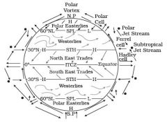
|
|
|
polar vortex |
A polar vortex is a large pocket of very cold air, typically the coldest air in the Northern Hemisphere, which sits over the polar region during the winter season |
|
|
valley breeze occurs during _______ and mountain breeze occurs during _______. |
day and night |
|
|
katabatic wind |
The coolair, of the high plateaus and ice fields draininginto the valley is called katabatic wind |
|
|
four types of fronts: |
four types of fronts: (a) Cold; (b) Warm; (c) Stationary; (d) Occluded. |
|
|
cold front and warm front |
When the cold air movestowards the warm air mass, its contact zone iscalled the cold front, whereas if the warm airmass moves towards the cold air mass, thecontact zone is a warm front. |
|
|
occluded front. |
If an air mass isfully lifted above the land surface, it is calledthe occluded front. |
|
|
middle latitude or extra tropical cyclones |
The systems developing in the mid and highlatitude, beyond the tropics are called themiddle latitude or extra tropical cyclones |
|
|
Extra tropical cyclones form along |
Extra tropical cyclones form along the polarfront. |
|
|
Extratropical cyclones form anywhere within |
Extratropical cyclones form anywhere within the extratropical regions of the Earth (usually between 30° and 60° latitude from theequator), |
|
|
Extratropical cyclones are generally driven, or "steered", by |
Extratropical cyclones are generally driven, or "steered", by deep westerly winds in a general west to east motion across both the Northern and Southern hemispheres of the Eart |
|
|
Extratropical cyclones derive their energy from |
Extratropical cyclones derive their energy from horizontal temperature contrasts. |
|
|
Extratropical cyclones typically form on a |
They typically form on a boundary between a warm and a cold air massassociated with an upper tropospheric jet stream |
|
|
cumulus clouds develop along |
cumulus clouds developalong the cold front |
|
|
speed cold vs warm front |
The cold front moves fasterthan the warm front ultimately overtaking thewarm front |
|
|
cyclone dissipates. |
The warm air is completely liftedup and the front is occluded and the cyclonedissipates. |
|
|
The extra tropical cyclone differs from thetropical cyclone in number of ways. (5) |
The extratropical cyclones have a clear frontal system which is not present in the tropical cyclones. extra tropical cyclones cover a larger area and can originate overthe land and sea. Whereas the tropical cyclonesoriginate only over the seas and on reachingthe land they dissipate. The extra tropicalcyclone affects a much larger area ascompared to the tropical cyclone. The windvelocity in a tropical cyclone is much higherand it is more destructive. The extra tropicalcyclones move from west to east but tropicalcyclones, move from east to west. |
|
|
Tropical cyclones are violent storms that originate over |
Tropical cyclones are violent storms thatoriginate over oceans in tropical areas andmove over to the coastal areas bringing aboutlarge scale destruction caused by violentwinds, very heavy rainfall and storm surges. |
|
|
Cyclones are known as |
They are known as Cyclones in the Indian Ocean, Hurricanes in the Atlantic, Typhoons in the Western Pacific and South China Sea, and Willy-willies in the Western Australia. |
|
|
The conditions favourable for the formation and intensification of tropical storms are |
The conditionsfavourable for the formation and intensificationof tropical storms are: (i) Large sea surface withtemperature higher than 27° C; (ii) Presenceof the Coriolis force; (iii) Small variations in thevertical wind speed; (iv) A pre-existing weaklow-pressure area or low-level-cycloniccirculation; (v) Upper divergence above the sealevel system. |
|
|
tropical cyclone dissipates over land |
On reaching the land themoisture supply is cut off and the stormdissipates. |
|
|
landfall of the cyclone |
The place where a tropical cyclonecrosses the coast is called the landfall of thecyclone. |
|
|
The cyclones, which cross 20o N latitude |
The cyclones, which cross 20o Nlatitude generally, recurve and they are moredestructive. |
|
|
The diameter of the tropical cyclone over the Bay of Bengal, Arabian sea and Indian ocean is |
The diameter of the storm overthe Bay of Bengal, Arabian sea and Indianocean is between 600 - 1200 km |
|
|
Tornadoes generally occur in |
Tornadoes generally occurin middle latitudes. The tornado over the seais called water spouts. |
|
|
dew point |
The temperature at which saturation occursin a given sample of air is known as dew point. |
|
|
Frost |
Frost forms on cold surfaces when condensation takes place below freezing point |
|
|
White frost |
White frost forms when there is a relative humidity above 90% and a temperature below −8 °C (18 °F) and it grows against the wind direction |
|
|
fog |
fog is a cloudwith its base at or very near to the ground |
|
|
difference between the mist and fog |
The only difference betweenthe mist and fog is that mist contains moremoisture than the fog. In mist each nucelicontains a thicker layer of moisture. |
|
|
According to their height, expanse, density and transparency or opaqueness clouds are grouped under four types |
According to their height,expanse, density and transparency oropaqueness clouds are grouped under fourtypes : (i) cirrus; (ii) cumulus; (iii) stratus; (iv) nimbus. |
|
|
Cirrus |
Cirrus clouds are formed at high altitudes.
They are thin and detachedclouds having a feathery appearance. They arealways white in colour. |
|
|
Cumulus |
Cumulus clouds look like cotton wool. Theyare generally formed at a height of 4,000 -7,000 m. They exist in patches and can be seenscattered here and there. They have a flat base. |
|
|
Stratus |
Stratus As their name implies, these are layered cloudscovering large portions of the sky. These cloudsare generally formed either due to loss of heator the mixing of air masses with differenttemperatures. |
|
|
Nimbus |
Nimbus Nimbus clouds are black or dark gray. Theyform at middle levels or very near to the surface of the earth. These are extremely dense andopaque to the rays of the sun |
|
|
these four basic types cangive rise to the following types of clouds |
these four basic types cangive rise to the following types of clouds: highclouds – cirrus, cirrostratus, cirrocumulus;middle clouds – altostratus and altocumulus; low clouds – stratocumulus and nimbostratus clouds with extensive verticaldevelopment – cumulus and cumulonimbus. |
|
|
The rainfall over oceans v/s landmasses ,which is more? |
The rainfall is more over theoceans than on the landmasses of the worldbecause of being great sources of water |
|
|
Intensity of rain on western and eastern margins of continents |
Between the latitudes 35 and 40 N and S ofthe equator, the rain is heavier on the easterncoasts and goes on decreasing towards thewest. But, between 45 and 65 N and S ofequator, due to the westerlies, the rainfall isfirst received on the western margins of thecontinents and it goes on decreasing towardsthe east. |
|
|
largest continental shelf in the world |
Siberian shelf in the Arctic Ocean, thelargest in the world |
|
|
Guyots |
GuyotsIt is a flat topped seamount |
|
|
submarine canyon example |
The Hudson Canyon isthe best known submarine canyon in the world. |
|
|
Thermocline |
This boundary region, from where there is arapid decrease of temperature, is called thethermocline. |
|
|
Layers of ocean and temperature |
first layer-20-25 degree celsius Thermocline-5-25 |
|
|
The highest temperature is not on equator but, |
The highesttemperature is not recorded at the equator butslightly towards north of it. |
|
|
The average annual temperatures for the northern and southern hemisphere are |
The average annualtemperatures for the northern and southernhemisphere are around 19° C and 16° Crespectively. This variation is due to theunequal distribution of land and water in thenorthern and southern hemispheres |
|
|
salinity is usually expressed as |
It is usually expressed as parts perthousand or ppt |
|
|
Factors affecting ocean salinity are: |
(i) evaporationand precipitation. (ii) incoastal regions - fresh water flowfrom rivers, and in polar regions - freezing and thawing of ice. (iii) Wind, also influences salinity of an areaby transferring water to other areas. (iv) The ocean currents contribute to thesalinity variations. Salinity, temperatureand density of water are interrelated. Hence,any change in the temperature or densityinfluences the salinity of water in an area. |
|
|
North sea v/s North atlantic drift salinity |
The North Sea,in spite of its location in higher latitudes,records higher salinity due to more saline waterbrought by the North Atlantic Drift. |
|
|
Baltic sea v/s Mediterranean sea-salinity |
Baltic Sea records low salinity due to influx of river waters in large quantity. The Mediterranean Searecords higher salinity due to high evaporation.Salinity is, however, very low in Black Sea dueto enormous fresh water influx by rivers. |
|
|
Bay of bengal v/s Arabian sea-salinity |
The low salinity trend is observed in the Bay of Bengal due to influx of river water. On the contrary, the Arabian Sea shows higher salinity due to high evaporation and low influx of fresh water. Figure 13.5 shows the salinity of the World’s oceans. |
|
|
halocline |
Salinity, generally, increases with depth and there is a distinct zone called the halocline where salinity increases sharply. |
|
|
wave breaks when |
whenthe depth of water is less than half the wavelength of the wave, the wave breaks. |
|
|
The largest waves are found in |
Thelargest waves are found in the open oceans |
|
|
The maximum wave height is determined by |
Themaximum wave height is determined by thestrength of the wind, i.e. how long it blows andthe area over which it blows in a single direction. |
|
|
Surge v/s Tides |
The periodical rise and fall of the sea level, onceor twice a day, mainly due to the attraction ofthe sun and the moon, is called a tide.
Movement of water caused by meteorologicaleffects (winds and atmospheric pressurechanges) are called surges. Surges are notregular like tides. |
|
|
Horizontal forces,vertical force-tide generation |
On thesurface of the earth, the horizontal tidegenerating forces are more important than thevertical forces in generating the tidal bulges |
|
|
The tidal bulges on wide continental shelves |
The tidal bulges on wide continentalshelves, have greater height. When tidal bulgeshit the mid-oceanic islands they become low. |
|
|
tidal currents |
Funnel-shaped bays greatly change tidalmagnitudes. When the tide is channelledbetween islands or into bays and estuariesthey are called tidal currents. |
|
|
Types of tides-frequency |
Diurnal-2 highs and 2 lows semi-diurnal- 1 high and low each mixed-tides with variations in height,occurs in west coast of North america |
|
|
Neap tide and spring tides |
Spring tide-When the sun, the moonand the earth are in a straight line, the heightof the tide will be higher. Neap Tide-At this time the sun and moon are atright angles to each other and the forces of thesun and moon tend to counteract one another |
|
|
tides during apogee and perigee of moon and earth |
Once in a month, when the moon’s orbit isclosest to the earth (perigee), unusually highand low tides occur. During this time the tidalrange is greater than normal. Two weeks later,when the moon is farthest from earth (apogee),the moon’s gravitational force is limited andthe tidal ranges are less than their averageheights. |
|
|
tidal power project India |
A 3 MW tidalpower project at Durgaduani in Sunderbansof West Bengal is under way. |
|
|
Tidal power potential India-highest at |
7000 MW at gulf of cambay 1200 MW at Rann of kutchh |
|
|
The primary forces that influence thecurrents are: |
The primary forces that influence thecurrents are: (i) heating by solar energy; (ii) wind; (iii) gravity; (iv) coriolis force |
|
|
How does heating cause ocean currents |
Heatingby solar energy causes the water to expand.That is why, near the equator the ocean wateris about 8 cm higher in level than in the middlelatitudes. This causes a very slight gradientand water tends to flow down the slope. |
|
|
Ocean Gyre |
An ocean gyre is a large system of circular ocean currents formed by global wind patterns and forces created by Earth's rotation. The movement of the world's major ocean gyres helps drive the “ocean conveyor belt. They are caused by coriolis force |
|
|
An ocean current is usually strongest at |
A current is usuallystrongest at the surface and decreasesin strength (speed) with depth. |
|
|
Cold current are found on |
cold currents bring coldwater into warm water areas. These currentsare usually found on the west coast of thecontinents in the low and middle latitudes(true in both hemispheres) and on the eastcoast in the higher latitudes in the NorthernHemisphere; |
|
|
warm currents are observed on |
warm currents bring warmwater into cold water areas and are usuallyobserved on the east coast of continents in thelow and middle latitudes (true in bothhemispheres). In the northern hemispherethey are found on the west coasts of continentsin high latitudes. |
|
|
The oceanic circulation pattern roughly corresponds to |
The oceanic circulation patternroughly corresponds to the earth’s atmosphericcirculation pattern. |
|
|
weather caused by anticyclones |
Calm settled weather is usually synonymous with anticyclones in temperate latitude |
|
|
Anticyclone |
"a large-scale circulation of winds around a central region of high atmospheric pressure, clockwise in the Northern Hemisphere, counterclockwise in the Southern Hemisphere |
|
|
Effects of surface-based anticyclones |
Effects of surface-based anticyclones include clearing skies as well as cooler, drier air |
|
|
major biomes of the world |
major biomes of the world. Thereare five major biomes — forest, desert, grassland,aquatic and altitudinal biomes |
|
|
Out of the total solar insolation that reaches the earth’s surface-% used for photosynthesis |
Out of the total solarinsolation that reaches the earth’s surface, onlya very small fraction (0.1 per cent) is fixed inphotosynthesis. |
|
|
biogeochemical cycles. |
These cyclicmovements of chemical elements of thebiosphere between the organism and theenvironment are referred to as biogeochemicalcycles. |
|
|
There are two types of biogeochemical cycles : |
There are two types of biogeochemicalcycles : the gaseous and the sedimentary cycle.In the gaseous cycle, the main reservoir ofnutrients is the atmosphere and the ocean. Inthe sedimentary cycle, the main reservoir is thesoil and the sedimentary and other rocks ofthe earth’s crust. |
|
|
Biodiversity can be discussed at threelevels :
|
Biodiversity can be discussed at threelevels : (i) Genetic diversity; (ii) Species diversity;(iii) Ecosystem diversity |
|
|
Genetic biodiversity |
Genetic biodiversity refers to thevariation of genes within species |
|
|
Species Diversity |
Species Diversity This refers to the variety of species |
|
|
Areas richin species diversity are called |
hotspots of diversity |
|
|
Ecosystem Diversity |
Diversity within an ecosystem. |